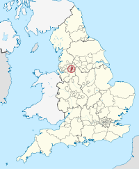
Leeds in England Map © by TUBS via wikipedia commons
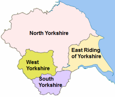
The city of Leeds is located in West Yorkshire in the North of England. The largest city in Yorkshire was historically known for its textile and wool manufacturing industries emerging as a major industrial centre during the Industrial Revolution. Heavy and manufacturing industry gradually closed down in the city bringing tough times for the city and its people. The city has since emerged with a change of economy and is now the second financial centre in England after London. Leeds is a university city and the administrative, commercial and cultural centre for the county of West Yorkshire with locals known as Loiners. Leeds attracts many visitors each year and is a favourite for weekend and shopping breaks with its shopping facilities heading it to be dubbed the ‘Knightsbridge of the North’.
Leeds Quick Facts
Population: 798,800
Region: Yorkshire & the Humber
Area total: 551.72 sq km
Languages: English
Demonym: Leodensian/Loiner
Dialling Code: 0113
Postcode Area CS
Closest Airports: Leeds International Airport, Doncaster Sheffield Airport.
Football Clubs: Leeds United and Leeds City.
Local Food: Yorkshire pudding, Parkin, & a wide choice of world foods.
Nearest Towns & Cities: Bradford, Doncaster, York, Huddersfield, Harrogate, Sheffield and Manchester.
Famous Attractions: Abbey House Museum, Kirkstall Abbey, Leeds City Art Gallery, Thackray Museum and Victoria Quarter.
Disclaimer: The information given in on this website is given in good faith and to the best of our knowledge. If there are any discrepancies in no way do we intend to mislead. Important travel details and arrangements should be confirmed and verified with the relevant authorities.