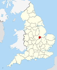
Rutland in England Map — GFDL via wikipedia commons
Rutland is located in the East Midlands in England, prominent towns in the area include Uppingham and Oakham, the county town. Rutland is a landlocked county that is one of the smallest in England, the county can be overlooked by some visitors given its relatively low profile. For those that do visit the scenic county, the rural environment offers a contrast to the hustle and bustle of the cities offering a more relaxed pace of life and a chance to enjoy the best in the English countryside.
Rutland is probably best known for Rutland Water, the area is popular with walkers and cyclists and is an important area for wildlife. Local attractions & places of interest include Oakham Castle, All Saints Church Oakham, Normanton Church, Lyddington Bede House, Rutland County Museum and Barnsdale Gardens. There are a number of historic buildings, castles, museums and galleries for visitors to explore in the area.
The area is host to a number of local festivals, shows and fairs throughout the year
Rutland Quick Facts
Population: 37,400
Region: East Midlands
Area total: 382 sq km
Languages: English
Dialling Code: 01572 (Oakham & Uppingham).
Postcode Area LE15 (Oakham & Uppingham).
Closest Airports: East Midlands Airport and Birmingham Airport.
Local Food: Rabbit Pithier, Dexter old spot burgers, port pies, Artisan Cheeses and locally brewed ciders and beers.
Nearest Towns & Cities: Uppingham and Oakham.
Famous Attractions: Oakham Castle, All Saints Church Oakham, Normanton Church, Lyddington Bede House, Rutland County Museum and Barnsdale Gardens.
.
Disclaimer: The information given in on this website is given in good faith and to the best of our knowledge. If there are any discrepancies in no way do we intend to mislead. Important travel details and arrangements should be confirmed and verified with the relevant authorities.
