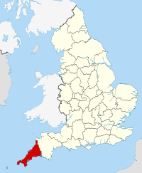
Cornwall in England Map — GFDL via wikipedia commons
Cornwall is located in South West England, prominent cities and towns in the area include Truro, Newquay, Falmouth and Penzance. Cornwall is the most southerly of England’s counties, the area enjoys a milder climate than most of the UK due to its location.
Cornwall has long been a favourite holiday destination, miles of scenic coastline and beaches, charming small towns and villages full of character and plenty of open spaces allowing visitors to get away from it all and enjoy the best of the scenic countryside Local attractions & places of interest include Cornwall and West Devon Mining Landscape (UNESCO World Heritage site), Tintagel Castle, Trewithen House and Gardens, the Eden Project and Land’s End. There are a number of historic buildings, castles, museums and galleries for visitors to explore in the area.
The area is host to a number of local festivals, shows, fairs and concerts throughout the year
Cornwall Quick Facts
Population: 535,300
Region: South West England
Area total: 3,546 sq km
Languages: English
Dialling Code: 01872 (Truro), 01637 (Newquay), 01326 (Falmouth).
Postcode Area TR1-4 (Truro), TR7 (Newquay), TR11 (Falmouth).
Closest Airports: Newquay Cornwall Airport (domestic), Exeter Airport.
Local Food: Scottish Beef, Artisan Cheeses, Oatcakes and Seafood varieties.
Nearest Towns & Cities: Falmouth, Newquay, Truro, Bodmin, St Ives and Penzance.
Famous Attractions: Cornwall and West Devon Mining Landscape (UNESCO World Heritage site), Tintagel Castle, Trewithen House and Gardens, the Eden Project and Land’s End
.
Disclaimer: The information given in on this website is given in good faith and to the best of our knowledge. If there are any discrepancies in no way do we intend to mislead. Important travel details and arrangements should be confirmed and verified with the relevant authorities.
